Thursday, March 27, 2014

What Happened to Malaysia Airlines Flight MH370

http://www.psychedelicadventure.net/2014/03/what-happened-to-malaysia-airlines.html


The Malaysian Airlines Flight MH370 disappeared into thin air while flying over the Gulf of Thailand on its way to Beijing from Kuala Lumpur Malaysia. The mystery over the missing plane with 239 people on board (227 passengers and 12 crew members) has deepened as some of the relatives of the passengers reported to the media stating that when they tried reaching their family members who were on the plane, their mobile phones were ringing hours after the flight went missing, off the radar. There is something strange about the whole incident as it seems to hint at something otherworldly or supernatural at play. Not so long ago an Air France Flight 447 went missing after it entered an electromagnetic storm cloud of sorts ... and disappeared without a trace. It does sound like a case of Teleportation like in the Bermuda Triangle !

A few relatives said they were able to call the cellphones of their loved ones or find them on a Chinese instant messenger service called QQ that indicated that their phones were still somehow online.

A migrant worker in the room said that several other workers from his company were on the plane, including his brother-in-law. Among them, the QQ accounts of three still showed that they were online, he said Sunday afternoon.

Adding to the mystery, other relatives in the room said that when they dialed some passengers' numbers, they seemed to get ringing tones on the other side even though the calls were not picked up.

Here are some other facts concerning the whole incident which leave a lot of questions unanswered ...

• Fact #1: All Boeing 777 commercial jets are equipped with black box recorders that can survive any on-board explosion

No explosion from the plane itself can destroy the black box recorders. They are bomb-proof structures that hold digital recordings of cockpit conversations as well as detailed flight data and control surface data.

• Fact #2: All black box recorders transmit locator signals for at least 30 days after falling into the ocean

Yet the black box from this particular incident hasn't been detected at all. That's why investigators are having such trouble finding it. Normally, they only need to "home in" on the black box transmitter signal. But in this case, the absence of a signal means the black box itself -- an object designed to survive powerful explosions -- has either vanished, malfunctioned or been obliterated by some powerful force beyond the worst fears of aircraft design engineers.

• Fact #3: Many parts of destroyed aircraft are naturally bouyant and will float in water

In past cases of aircraft destroyed over the ocean or crashing into the ocean, debris has always been spotted floating on the surface of the water. That's because -- as you may recall from the safety briefing you've learned to ignore -- "your seat cushion may be used as a flotation device."

Yes, seat cushions float. So do many other non-metallic aircraft parts. If Flight 370 was brought down by an explosion of some sort, there would be massive debris floating on the ocean, and that debris would not be difficult to spot. The fact that it has not yet been spotted only adds to the mystery of how Flight 370 appears to have literally vanished from the face of the Earth.

• Fact #4: If a missile destroyed Flight 370, the missile would have left a radar signature

One theory currently circulating on the 'net is that a missile brought down the airliner, somehow blasting the aircraft and all its contents to "smithereens" -- which means very tiny pieces of matter that are undetectable as debris.

The problem with this theory is that there exists no known ground-to-air or air-to-air missile with such a capability. All known missiles generate tremendous debris when they explode on target. Both the missile and the debris produce very large radar signatures which would be easily visible to both military vessels and air traffic authorities.

• Fact #5: The location of the aircraft when it vanished is not a mystery

Air traffic controllers have full details of almost exactly where the aircraft was at the moment it vanished. They know the location, elevation and airspeed -- three pieces of information which can readily be used to estimate the likely location of debris.

Remember: air safety investigators are not stupid people. They've seen mid-air explosions before, and they know how debris falls. There is already a substantial data set of airline explosions and crashes from which investigators can make well-educated guesses about where debris should be found. And yet, even armed with all this experience and information, they remain totally baffled on what happened to Flight 370.

• Fact #6: If Flight 370 was hijacked, it would not have vanished from radar

Hijacking an airplane does not cause it to simply vanish from radar. Even if transponders are disabled on the aircraft, ground radar can still readily track the location of the aircraft using so-called "passive" radar (classic ground-based radar systems that emit a signal and monitor its reflection).

Thus, the theory that the flight was hijacked makes no sense whatsoever. When planes are hijacked, they do not magically vanish from radar.

)

The possibility that the plane went through some kind of a space-time warp or wormhole is definitely not ruled out as it does remind one of the mysterious Bermuda Triangle where planes have known to experience similar anomalies and some have in fact disappeared without a trace. I feel some of these planes could have entered a wormhole of sorts to go into an alternate / parallel timeline. If this sounds like science fiction then we must gear up for the surprise of our lifetime as we come face to face with the truth which would then make this possibility more plausible.

Here is something interesting you might want to watch :)

)

Wednesday, March 26, 2014

Pasangan Suami Istri di Bogor Ini Tahu Lokasi Jatuhnya Malaysia Airlines

http://www.tribunnews.com/internasional/2014/03/16/pasangan-suami-istri-di-bogor-ini-tahu-lokasi-jatuhnya-malaysia-airlines

TRIBUNNEWS.COM, BOGOR - Sudah lebih dari seminggu sejak pesawat Malaysia Airlines MH370 hilang kontak pada Sabtu (8/3/2014) lalu. Pencarian pun terus dilakukan, namun sampai saat ini belum ada titik terang dimana keberadaan pesawat yang mengangkut 239 penumpang dan awak pesawat itu.
Pasangan suami istri Fajar Sahari (58) dan Winarti (52) turut mengikuti perkembangan proses pencarian pesawat yang juga berpenumpang warga negara Indonesia tersebut.
Keduanya, yang mengaku diberi anugerah mampu berkomunikasi dengan alam gaib, merasa prihatin dengan musibah tersebut dan bermaksud membantu dengan cara yang mereka.
"Ya kita hanya memberikan informasi, sebagai sesama harus saling membantu. Kami tidak mengharapkan apa-apa," ujar Fajar saat ditemui Tribun di kediamannya di Jalan Batara Nomor 93, Kampung Parikolot, Ciluar, Bogor, Minggu (16/3/2014).
Menurut Fajar informasi yang mereka peroleh menyebutkan pesawat berada di titik berikut (LU 7 derajat 47'47.90" Bujur Timur 105 derajat 13'39.59" Elev -30m. Ketinggian mata 5 m. Atau berada di sekitar selatan ibukota Vietnam, Ho Chi Minh.
Keduanya kemudian menuturkan bagaimana proses mereka mendapatkan informasi terkait keberadaan pesawat sampai dengan titik koordinatnya. Menurut Fajar, sang istri mengetahui lokasi pesawat setelah melakukan komunikasi dengan awak pesawat naas tersebut.
Winarti ia sebut memang memiliki kemampuan khusus untuk berkomunikasi dengan hal-hal gaib dan sudah beberapa kali terjadi dan terbukti.
Fajar menuturkan, pada hari Kamis (13/3/2014) siang, usai melaksanakan salat Zuhur, Winarti memohon doa agar bisa diberi petunjuk mengenai keberadaan lokasi pesawat Malaysia Airlines MH370.
Tiba-tiba muncul sosok seorang pria dengan pakaian layaknya seorang kru pesawat datang dan berkomunikasi dengan Winarti.
"Mungkin copilot atau siapa, yang jelas pakai seragam," tuturnya.
Pria itu kemudian menuturkan kepada Winarti bagaimana pesawat tersebut tiba-tiba mati seluruh perangkatnya ketika melintas di Laut China Selatan, tepatnya sebelah selatan Vietnam.
Pesawat yang tiba-tiba kehilangan power secara total itu kemudian jatuh dan tenggelam ke dasar laut, lengkap dengan para penumpang dan awak kapal di dalamnya. Jeritan teriakan takbir pun terdengar saat pesawat mula jatuh ke laut.
"Pesawatnya utuh, enggak meledak, enggak ada serpihan apa-apa. Penumpang masih duduk di kursi masing-masing dengan sabuk pengaman terpasang," ujar Winarti yang mengaku sempat diberi penglihatan kondisi pesawat di dasar laut.
Winarti menuturkan semua penumpang sudah dalam keadaan meninggal dunia di kursi masing-masing, dengan sabuk pengaman masih terpasang.
Ia mengaku saat diberi penglihatan itu tak sanggup menahan air matanya yang tumpah melihat pemandangan memilukan tersebut, apalagi Winarti sempat melihat dua orang anak kecil di antara penumpang yang tewas.
Terlebih si pria berpakaian awak kapal itu kemudian sempat menitipkan pesan kepadanya untuk disampaikan kepada anak perempuannya yang masih kecil.
"Dia bilang salam buat anakku sambil tersenyum. Anaknya itu rambutnya keriting-keriting, anak perempuan sekitar umur 7-9 tahun," imbuhnya.
Menurut Winarti, pada saat berkomunikasi yang pertama itu, ia tidak sempat mendapatkan lokasi jatuhnya pesawat.
Titik koordinat lokasi baru ia dapatkan pada Jumat dinihari, ketika ia kembali melakukan komunikasi dengan awak kapal Malaysia Airlines itu setelah melakukan salat Tahajud. (Baca: Pasangan Suami Istri di Bogor Ini Tahu Lokasi Jatuhnya Malaysia Airlines).
Winarti menuturkan, komunikasi yang kedua ia lakukan bukan dengan orang yang sama saat melakukan komunikasi pertama. Pada saat komunikasi kedua itu, lelaki berbeda yang kemudian ia tahu adalah pilot pesawat Zahari Ahmad Shah.
Dari Zahari inilah kemudian Winarti dan Fajar Sahari memperoleh koordinat yang mereka duga adalah lokasi jatuhnya pesawat naas tersebut. Ia juga menuturkan bagaimana pesawat yang awalnya mengarah ke utara sempat berbelok ke arah barat sebelum kemudian berputar ke arah timur dan terjatuh.
"Makanya badan pesawat itu menghadap timur," ujar Fajar.
Arah pesawat yang goyang dan kemudian terjatuh, menurut Fajar kemungkinan diakibatkan arus magnet yang kuat di dasar laut di sekitar lokasi jatuhnya pesawat. Pesawat itu kemudian tiba-tiba mati total dan jatuh tenggelam ke dalam laut.
Zahari juga mengatakan kepada Winarti bahwa dunia itu penuh keajaiban, entah apa maksudya Winarti sendiri tidak tahu.
"Ya mungkin maksudnya, apa yang enggak mungkin jadi mungkin, yang penting cari dulu. Saya juga enggak tahu artinya," ujarnya
Sempat Melapor ke Danlanud
Fajar mengaku hanya berniat membantu proses pencarian pesawat yang telah memakan waktu lebih dari seminggu itu.
Ia menyebut dirinya tidak memiliki maksud apa-apa, yang terpemnting baginya adalah pesawat bisa diketemukan dan keluarga korban bisa lebih lega dan ikhlas menerima kenyataan.
Untuk itu, Fajar menyebut dirinya sudah melaporkan informasi yang ia dapat itu ke beberapa pihak yang ia anggap memiliki akses untuk menggunakan info tersebut untuk menemukan pesawat tersebut.
"Saya sudah hubungi Komandan Lanud Soewondo Kolonel SM Handoko serta duta besar di Vietnam Bambang Tarsanto (Konjen di Ho Chi Minh City) via SMS," tuturnya.
Selain itu ia juga sempat mendatangi sebuah stasiun televisi swasta dan diberitahu akan diberi kesempatan tampil live setelah menunggu persetujuan salah satu penanggung jawab program. Namun setelah menunggu lama, justru yang ditunggu itu pulang dan ia tidak diberi tahu apa-apa.
Fajar mengatakan dirinya sama sekali tidak mengharapkan apa-apa, yang terpenting baginya adalah pesawat dapat segera ditemukan.
Mengenai kemampuan berkomunikasi dengan hal-hal gaib, Fajar mengaku tidak menjalani ritual apapun, ia dan istrinya hanya diberi tanggung jawab oleh tuhan untuk membantu sesama.
"Saya pernah bantu teman cari anak perempuannya yang hilang, dan hasil informasi yang didapat itu benar. Saya dan istri juga pernah mendapat informasi soal keberadaan mata air di Banyuwangi, dan ternyata benar terbukti," ujarnya.

Saturday, March 22, 2014

MH370: I Speak Out

Source:  http://seademon.wordpress.com/2014/03/20/mh370-i-speak-out/
 20140319-225404.jpg This posting is made with the above in mind. A lot has been said about the disappearance of the MH370. Most of what has been said are purely speculations, with some that might have qualified to be nominated for best screenplay at the Academy Awards. I, too, have some idea of what might have happened but I put them aside so I could listen to the daily press conference with an open mind. I will also attempt to maintain some form of ethics because I also have the feelings of the family of the passengers and crew in mind when I write this.
The Royal Malaysian Air Force (RMAF) has come under intense attack by both foreign and local media alike. The Air Defence system has also come under intensive fire by members of the opposition party for its failure to detect the MH370 upon deviating from its intended path and the subsequent failure to scramble our fighters. Some even say our air defence personnel were asleep on the job, and that at least one air defence radar was not working.
It is easy for keyboard warriors to criticise the RMAF without knowing what or how our air defence systems work. Perhaps when they think of an air defence system, they had the following in mind:
20140319-230523.jpg
Why I write this is to give a general understanding of how our air defence system works, and what really happened that night. I have been generally quiet on this matter as at the time of writing, I am grieving the passing of my younger brother exactly 100 days today. But duty calls, I guess.
I left the RMAF almost 20 years ago. A handful of my squad-mates are still serving senior officers. Back in September 2012, a number of bloggers (including I) and some senior editors of the Malaysian media (including those that are opposition-leaning) were invited to a media open day organised by the then Minister of Defence. Everything was displayed to us, including some of the very sensitive information, so that we could acquire enough background and understand how the RMAF works. Out of the 80 or so people who were there that day, I guess I am the only one to come to the defence of the RMAF.
First of all, this is how a typical air defence centre looks like from the inside:
20140319-231314.jpg
It is no longer the one-man show you see in the movie “Tora! Tora! Tora!” There are several air defence centres around Malaysia covering both the Peninsula, Sabah, Sarawak and FAR beyond. I have a photo of how far our air defence radars reach, but although I was allowed to take photos of the main display, I opt not to put it up here. Suffice to say, what we have is enough to tell us way ahead if a hostile aircraft is approaching our airspace. When we were at the air defence centre, we were shown a live interception of two bogeys by two of our MiG-29N interceptors.
20140319-231902.jpg
If I may say, what we all saw on the screen was what would have been seen by all the operators of the other RMAF Air Defence Centres around the nation that if one failed, it would not jeopardise what the others could see.
During this display, not one journo nor blogger could come up with a sane question related to what was shown to them. In the end, I and a few of my blogger friends had to ask the questions to get the RMAF clarify on issues that the media and bloggers have been attacking them on. Even the Deputy Chief of Air Force, Lieutenant General Dato Seri Haji Roslan bin Saad thanked me for my participation and for helping the RMAF clarify some issues.
Let us go back to that wee hours on Saturday, 8th March 2014. MH370 took off from Kuala Lumpur International Airport at 0041 hours (Local Time). At 0107 hours, the Aircraft Communications Addressing and Reporting System (ACARS) transmitted that all was well with the aircraft.
The aircraft soon after arrived at waypoint IGARI, about 78 nautical miles from Redang island, bearing 056 degrees) which is a point in the South China Sea between the Malaysian border with Vietnam. At this point, Lumpur Flight Information Region (FIR) would hand over the control aircraft to Vietnam. At 0119 hours, a person believed to be the co-pilot transmitted the final vox transmission, “Alright, good night.” At 0122 hours, the aircraft disappeared from secondary radar coverage without any distress call suggesting its transponder had been switched off by someone on the flight deck. However, it was only at 0240 hours that Malaysia Airlines was notified.
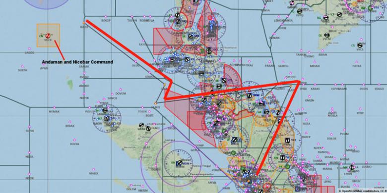
The RMAF Air Defence radars saw the MH370 tracked West Southwest to waypoint VAMPI (68 nautical miles East Northeast of Lhokseumawe, Indonesia), then Northeast to waypoint GIVAL (69 nautical miles South Southwest of Phuket International Airport) before tracking Northwest towards waypoint IGREX (100 nautical miles East Southeast of Car Nicobar airport on India’s Nicobar Islands), the last known position according to the primary radar. Where MH370 went to after this point is unknown at this point, but I believe the Indian Air Force’s Andaman and Nicobar Command’s primary radar there would have caught the MH370 in its scope.
So, if the MH370 was seen to deviate from its intended course, why didn’t the RMAF scramble its fighters to intercept the airliner?
Every bogey (unknown aircraft) would be tagged by an Air Defence Officer and this data will be processed to ascertain whether it was a threat to air defence or otherwise. In the case of the MH370, it was not regarded as hostile. Is this a weakness on the part of the RMAF? Mind you three jetliners took down the World Trade Centre towers as well as the Pentagon in the sophisticatedly-defended United States of America.
Should our fighters have been scrambled? If you remember, the MH370 was no longer in our airspace. When the MH370 tracked West Southwest from IGARI to VAMPI, she did not cross Malaysian airspace. She flew over Thai airspace and into Indonesian airspace, then tracked up to GIVAL near Phuket and subsequently to IGREX near India’s Nicobar Islands (see below).
20140320-001239.jpg
When she tracked from IGARI to IGREX she entered an area with two Royal Thai Air Force fighter bases namely the RTAF 7th Wing in Surat Thani and the 56th Wing in Hat Yai. They, too, were not scrambled. Nor were the fighters of the Indonesian Air Force (TNI-AU) scrambled from Lhokseumawe or Banda Aceh in Aceh, or Suwondo in Medan. If you think the Indonesians are as incapable as the RMAF, they forced a US military transport down without scrambling their fighters at their base in Banda Aceh on 20th May 2013 for entering Indonesian airspace without proper clearance.
The Chief of Air Force, General Tan Sri Dato Seri Rodzali bin Daud have explained that the RMAF did not see the need to scramble its fighters as the blip on the primary radar was deemed not hostile, and that there was nothing wrong with the air defence system. I just find this attack on the RMAF as another cheap publicity shot by a bunch of losers who do not know how things work and why, and would just take pot shots and see what gets hit.
I know the RMAF I see now is a far advanced RMAF than the one I left almost 20 years ago, and I have faith in the officers, men and women in their capability to defend this nation. I cannot say the same for the group of losers bent on hitting out at any institution of His Majesty Yang DiPertuan Agong.
To these losers, please just STFU!

Tuesday, March 18, 2014

Hyderabad techie uploads satellite image of missing plane on CNN site

Sebuah foto satelit yang diduga pesawat Boeing 777 MH730.


Namun demikian pakar avionik Gerry Soejatman, foto itu bukan Boeing 777:


Teks dari artikel tersebut:

================

Going about his work nonchalantly at his office in Gachibowli, this techie probably beat search teams of various countries in finding a probable vital clue related to the missing Malaysian plane.
An IT analyst by profession, Anoop Madhav Yeggina had been scurrying through innumerable images of DigitalGlobe Satellite QB02 over the past few days until he stumbled upon an image which almost took his breath away.

He had found a satellite image of a large aircraft flying very low above the Andaman Islands on March 8 which he believes is the Boeing 777 of Malaysian airlines.

The 29-year-old is among the lakhs of people from across the globe involved in the ‘crowd-sourcing’ project to find the missing plane with more than 200 passengers on board. He had uploaded his “discovery” along with a write-up on the CNN website on Friday, March 14, and since then received more than 16,000 views, followed by many comments from viewers. “I am confident that the image is that of the missing plane because of many reasons. First giveaway is the fact that the image was captured just above a forest and very close to the Shibpur air strip of Andaman Islands. The air strip is exclusively used by the defence forces with no permission for civilian aircraft in this area. A close look at the image will reveal if it is flying extremely low so much so that the clouds are above it which suggests it was done to avoid detection by radar. Most importantly, the standard scale measurement and colour of the missing plane matches with that of the plane in the image,” said Mr. Anoop. Wishing for safety of the passengers, he had appealed online to people with technical know-how of aircraft to further investigate the image in order to trace its whereabouts.


===
REF: http://m.thehindu.com/news/cities/Hyderabad/hyderabad-techie-uploads-satellite-image-of-missing-plane-on-cnn-site/article5801884.ece

Missing Malaysia Airlines Flight MH370: Did jetliner fly into area controlled by Taliban?

Source: http://www.independent.co.uk

Missing Malaysia Airlines Flight MH370: Did jetliner fly into area controlled by Taliban? Net widens after claims final satellite signal could have been sent from the ground.


The missing Malaysian airlines flight MH370 may have been deliberately flown under the radar to Taliban-controlled bases on the border of Afghanistan, it has emerged, as authorities said that the final message sent from the cockpit came after one of the jet's communications systems had already been switched off.

Eight days after the Boeing 777 vanished, The Independent has learnt that Malaysian authorities are seeking diplomatic permission to investigate a theory that the plane was flown to one of a number of Taliban strongholds on the Afghan border in North West Pakistan.

The latest revelation came as it was revealed that the final message sent to air traffic controllers from the jet's cockpit - “ All right, good night” - was spoken after someone on board had already disabled the plane's ACARS reporting system.

Around 14 minutes later someone also switched off the plane's transponder, which identifies it to commercial radar systems. Malaysian Air force Major General Affendi Buang told reporters that the two separate actions, along with the calm message in between, “will tell you something” about whether the diversion was deliberate or not.

At least 25 countries are now assisting in the search for the plane, intensifying challenges of co-ordinating ground, sea and aerial efforts. Countries known to be involved include Uzbekistan, Pakistan, Kyrgyzstan, Burma, Laos, Vietnam, Thailand, Indonesia and Australia, with special assistance regarding satellite data requested from the US, China and France.

On Sunday Malaysian officials examined a sophisticated flight simulator belonging to the chief pilot of the missing jet, after experts said only a trained person could have turned off the plane’s communication equipment and flown it off course without being detected.

Working on the theory that the plane was intentionally flown off course, police have delved into the backgrounds of captain Zaharie Ahmed Shah, 53, and 27-year-old co-pilot Fariq Abdul Hamid. Their homes were searched on Saturday, and on Sunday, experts examined the simulator Mr Shah kept in his home which he had built himself.

There have been no reported sightings or concrete leads on the whereabouts of the jet, which vanished from radar screens shortly after it took off in Kuala Lumpur at 00.40am on the morning of 8 March, destination Beijing.
The final confirmed location for MH370 on civilian radar was at 1.21am, but it was spotted less than an hour later on military radar, far to the west of that position. Malaysian Prime Minister Najib Razak revealed that “ping” signals from the plane was last received at 8.11am.
 
Based on data collated by the British company Inmarsat’s satellite network, at that point the plane was on one of two possible arcs – one stretching north from Thailand to Kazakhstan and crossing more than 10 countries, and one to the south over Indonesia and out across the southern Indian ocean. Experts have said the aircraft could have been on the ground when it sent its satellite signals.

Boeing 777s need a runway of at least 5,000ft long, limiting the number of possible sites within the 2,200 nautical mile-radius it is believed the plane could have flown from its last known position.
Last night sources in Kuala Lumpur assisting with the investigation told The Independent that full diplomatic permissions were being sought in order to rule out the theory that the plane could have flown to areas of Afghanistan and Pakistan that are not under government control.
Large areas of the southern half of Afghanistan are ruled by the Afghan Taliban, while some areas of north-west Pakistan, adjacent to or near to the Afghan border, are controlled by the Pakistani Taliban.

A spokesman for Malaysian Airlines said: “These are matters for the jurisdiction of those regions and Malaysia’s armed forces and department of civil aviation. In regard to Pakistan and Afghanistan, we cannot explore those theories without permission. We hope to have that soon.”
For a commercial plane to pass undetected through these regions, which are highly militarised with robust air defence networks, many run by the US military, would require a combination of extremely sophisticated navigation, brazen audacity and security failure by those monitoring international airspace. However, with so little known about the fate of the plane, and the investigation growing in scale every day, it is yet another line of enquiry that remains impossible to rule out. On Sunday Pakistani civil aviation officials said they had checked their radar recordings and found no sign of the missing jet.

Malaysian officials said they had requested help from a dozen Asian countries and had asked them to provide radar data. They have also asked for assistance from Vietnam, Thailand, Indonesia, Australia and France, which administers a handful of islands deep in the southern Indian Ocean.


“The search area has been significantly expanded, and the search area has changed. We are now looking at large tracts of land, crossing 11 countries as well as deep and remote oceans,” said Malaysia’s Transport Minister Hishammuddin Hussein.
Khalid Abu Bakar, Malaysia’s police chief, said investigators researching the backgrounds of the people who boarded Flight MH370 had found no passengers with aviation expertise. He said a number of foreign intelligence agencies had been working with the Malaysians, though he said information was still pending from some countries with nationals on the flight.
Police are looking at the personal, political and religious backgrounds of all crew members. A number of ground support staff who might have worked on the plane are also being investigated.
Officials urged reporters not to jump to conclusions on the pilot and co-pilot, who they said had not asked to work together that day, and had not requested additional fuel for the aircraft.
Reuters reported police had said their inquiries had found no links between Captain Shah and any militant group.

MH370 A different point of view

From:  https://plus.google.com/106271056358366282907/posts/GoeVjHJaGBz

MH370  A different point of view. Pulau Langkawi 13,000 runway.

A lot of speculation about MH370. Terrorism, hijack, meteors. I cannot believe the analysis on CNN - almost disturbing. I tend to look for a more simple explanation of this event.

Loaded 777 departs midnight from Kuala to Beijing. Hot night. Heavy aircraft.  About an hour out across the gulf towards Vietnam the plane goes dark meaning the transponder goes off and secondary radar tracking goes off.

Two days later we hear of reports that Malaysian military radar (which is a primary radar meaning the plane is being tracked by reflection rather than by transponder interrogation response) has tracked the plane on a southwesterly course back across the Malay Peninsula into the straits of Malacca.

When I heard this I immediately brought up Google Earth and I searched for airports in proximity to the track towards southwest.

The left turn is the key here. This was a very experienced senior Captain with 18,000 hours. Maybe some of the younger pilots interviewed on CNN didn't pick up on this left turn. We old pilots were always drilled to always know the closest airport of safe harbor while in cruise. Airports behind us, airports abeam us and airports ahead of us. Always in our head. Always. Because if something happens you don't want to be thinking what are you going to do - you already know what you are going to do. Instinctively when I saw that left turn with a direct heading I knew he was heading for an airport. Actually he was taking a direct route to Palau Langkawi a 13,000 foot strip with an approach over water at night with no obstacles. He did not turn back to Kuala  Lampur because he knew he had 8,000 foot ridges to cross. He knew the terrain was friendlier towards Langkawi and also a shorter distance.

Take a look on Google Earth at this airport. This pilot did all the right things. He was confronted by some major event onboard that made him make that immediate turn back to the closest safe airport.
For me the loss of transponders and communications makes perfect sense if a fire. There was most likely a fire or electrical fire. In the case of fire the first response if to pull all the main busses and restore circuits one by one until you have isolated the bad one.


If they pulled the busses the plane indeed would go silent. It was probably a serious event and they simply were occupied with controlling the plane and trying to fight the fire. Aviate, Navigate and lastly communicate. There are two types of fires. Electrical might not be as fast and furious and there might or might not be incapacitating smoke. However there is the possibility given the timeline that perhaps there was an overheat on one of the front landing gear tires and it blew on takeoff and started slowly burning. Yes this happens with underinflated tires. Remember heavy plane, hot night, sea level, long run takeoff. There was a well known accident in Nigeria of a DC8 that had a landing gear fire on takeoff. A tire fire once going would produce horrific incapacitating smoke. Yes, pilots have access to oxygen masks but this is a no no with fire. Most have access to a smoke hood with a filter but this will only last for a few minutes depending on the smoke level. (I used to carry one of my own in a flight bag and I still carry one in my briefcase today when I fly).

What I think happened is that they were overcome by smoke and the plane just continued on  the heading probably on George (autopilot) until either fuel exhaustion or fire destroyed the control surfaces and it crashed. I said four days ago you will find it along that route - looking elsewhere was pointless.

This pilot, as I say, was a hero struggling with an impossible situation trying to get that plane to Langkawi. No doubt in my mind. That's the reason for the turn and direct route. A hijack would not have made that deliberate left turn with a direct heading for Langkawi. It would probably have weaved around a bit until the hijackers decided on where they were taking it.

Surprisingly none of the reporters , officials, other pilots interviewed have looked at this from the pilot's viewpoint. If something went wrong where would he go? Thanks to Google earth I spotted Langkawi in about 30 seconds, zoomed in and saw how long the runway was and I just instinctively knew this pilot knew this airport. He had probably flown there many times. I guess we will eventually find out when you help me spread this theory on the net and some reporters finally take a look on Google earth and put 2 and 2 together. Also a look at the age and number of cycles on those nose tires might give us a good clue too.  

Fire in an aircraft demands one thing - you get the machine on the ground as soon as possible. There are two well remembered experiences in my memory. The AirCanada DC9 which landed I believe in Columbus Ohio in the eighties. That pilot delayed descent and bypassed several airports.   He didn't instinctively know the closest airports. He got it on the ground eventually but lost 30 odd souls.   In the 1998 crash of Swissair DC-10 off Nova Scotia was another example of heroic pilots. They were 15 minutes out of Halifax but the fire simply  overcame them and they had to ditch in the ocean. Just ran out of time. That fire incidentally started when the aircraft was about an hour out of Kennedy. Guess what the transponders and communications were shut off as they pulled the busses.


Get on Google Earth and type in Pulau Langkawi  and then look at it in relation to the radar track heading. 2+2=4  That for me is the  simple explanation why it turned and headed  in that direction.

Smart pilot. Just didn't have the time.

Ini Bukti Malaysia Airlines MH370 Sengaja Hindari Radar

Sumber: http://tekno.kompas.com/read/2014/03/15/2102528/Ini.Bukti.Malaysia.Airlines.MH370.Sengaja.Hindari.Radar

KOMPAS.com - Meski Pemerintah Malaysia belum memastikan hilangnya pesawat Malaysia Airlines MH 370 karena aksi pembajakan, namun dugaan skenario pembajakan terhadap pesawat yang hilang sejak Sabtu pekan yang lalu (8/3/2014) kini semakin kuat.

Dugaan muncul setelah Perdana Menteri Malaysia, Najib Razak mengadakan konferensi pers di Malaysia, hari ini Sabtu (15/3/2014).  Dalam konferensi pers tersebut, Razak menyatakan, pesawat Boeing 777-200ER milik maskapai Malaysian Airlines sengaja dibelokkan dan  dimatikan radar transponder-nya.

Apa yang disampaikan oleh Razak dalam konferensi pers hari ini memunculkan dugaan bahwa pembajak MH370 bukan orang sembarangan, setidaknya ia mengetahui teknis pengoperasian instrumen pesawat. Karena, selain membelokkan rute dan mematikan transponder, pihak yang mengambilalih pesawat dengan sengaja memilih jalur untuk menghindari radar agar tidak terdeteksi.

Fakta di atas diperkuat dengan data yang didapat oleh Reuters. Pada Jumat (14/3/2014), Reuters mendapatkan data lokasi MH370 yang ditangkap radar militer Malaysia setelah menghilang dari radar sipil. Data tersebut didapat Reuters dari sumber kepolisian Malaysia yang tidak mau disebutkan namanya.

Dari data tersebut, diketahui MH370 berada di waypoint yang bernama IGARI pada Sabtu (8/3/2014) pekan lalu, pukul 01:21 pagi waktu Malaysia. Waypoint IGARI sendiri berada di radial 059 derajat dari radar VOR Kota Bharu.

Setelah itu, MH370 bergerak ke arah barat menuju waypoint VAMPI yang berada di Selat Malaka, atau timur laut Banda Aceh, Indonesia tanpa terdeteksi radar sipil.

Setelah mencapai titik VAMPI, MH370 berbelok sedikit ke timur laut menuju waypoint GIVAL yang berada di selatan Phuket, Thailand, lalu terbang ke arah barat laut menuju waypoint IGREX yang berada di tengah laut Andaman.

Radar militer Malaysia kemudian tidak bisa menjejak lagi kemana MH370 pergi. Dari waypoint IGREX, terdapat rute airways P628 yang sering digunakan oleh pilot untuk terbang dari wilayah Asia Tenggara menuju Timur Tengah atau Eropa.

Dari pemilihan jalur seperti dijelaskan di atas, bisa disimpulkan bahwa siapa saja yang membelokkan penerbangan MH370 adalah orang yang memiliki pengetahuan yang cukup.

Hal tersebut juga diutarakan oleh Associated Press (AP) yang mengatakan bahwa satu orang atau lebih yang memiliki pengetahuan terbang yang signifikan telah membajak Malaysian Airlines MH370.

Orang tersebut tahu bagaimana cara mematikan transponder pesawat, dan memberikan input navigasi yang baru, menyimpang dari rute yang telah diatur untuk terbang menuju Beijing.

Rute MH370 digambarkan oleh grafis yang terdapat di situs http://irinfodotorg.files.wordpress.com di bawah ini. File resolusi tinggi dari foto di bawah bisa dibuka melalui tautan ini.


http://airinfodotorg.files.wordpress.com/
Waypoint pesawat Malaysia Airlines MH370. Sumber: http://airinfodotorg.files.wordpress.com/
Dari waypoint IGREX di tengah laut Andaman tersebut, MH370 diperkirakan masih memiliki bahan bakar untuk terbang selama 5 jam. Karena itulah, saat ini fokus pencarian Boeing 777-200 Malaysian Airlines tersebut dikonsentrasikan dari batas utara di Tajikistan hingga batas selatan di Samudera Hindia.

MH370 sengaja menghindari radar?

Layaknya jalan raya, pesawat terbang di udara juga harus melewati jalur yang sudah ditentukan, jalur udara tersebut disebut airways yang menghubungkan dari satu waypoint ke waypoint berikutnya. Dalam pesawat terbang modern, seperti Boeing 777-200ER milik Malaysian Airlines ini, pesawat juga sudah dilengkapi dengan komputer penerbangan (Flight Management Computing-FMC).

Melalui FMC inilah, pilot memberikan input waypoint dan airways mana yang akan digunakan dalam satu rute penerbangan, lengkap dengan informasi lain seperti ketinggian jelajah, berat pesawat, bahan bakar, dan sebagainya.

Karena itu, fakta bahwa MH370 terbang dari satu waypoint ke waypoint berikutnya, bukan terbang ke bebas ke sembarang arah, menguatkan dugaan orang yang berpengalaman yang menerbangkan MH370 keluar dari jalurnya.

Rute yang diambil oleh MH370 setelah mematikan transponder juga terkesan mencurigakan. Pasalnya jika ditarik garis lurus, maka rute baru yang ditempuh MH370 tersebut seolah terbang menghindari radar pengawas.

Untuk diketahui, wilayah udara terbagi atas beberapa FIR (Flight Information Region: http://en.wikipedia.org/wiki/Flight_information_region) yang dikontrol oleh masing-masing negara. Sesaat sebelum hilang dari waypoint IGARI, MH370 mematikan transpondernya. IGARI berada di batas antara FIR Singapura dan FIR Ho-Chi-Minh, Khusus untuk FIR Singapura yang ada di laut China Selatan ini, koridor utara dikontrol oleh pihak Malaysia.


Foto Kuala Lumpur FIR. Sumber: http://www.swld.com.au/images/air_asia_FIR.jpg
Sesaat sebelum meninggalkan FIR yang dikontrol Malaysia dan hendak masuk ke FIR Ho-Chi-Minh (Vietnam), MH370 mematikan transponder dan mengubah arah menuju ke waypoint VAMPI hingga IGREX, yang seolah terbang di tepian batas antar FIR berbagai negara, yaitu Ho-Chi-Minh, Bangkok dan Yangon.

Sayangnya, radar militer Malaysia tak bisa menjejak MH370 selepas waypoint IGREX. Saat ditanya oleh Reuters tentang seberapa luas cakupan radar militer Malaysia, Menteri Transportasi Malaysia, Hishammuddin Hussein menolak untuk menjawab, sebab hal tersebut menurutnya adalah informasi yang sensitif.

Banyak komentar yang muncul setelah informasi mengenai keberadaan terakhir MH370 ini diungkap. Mengapa pihak Malaysia baru memunculkan data tujuh hari setelah hilangnya MH370 juga dipertanyakan, mengingat semua sumber daya yang ada selama ini justru dikerahkan di laut China Selatan.

Kini Perdana Malaysia telah memerintahkan semua sumber daya untuk dikerahkan melakukan pencarian di wilayah yang baru, berdasar posisi terakhir MH370 menurut radar militer Malaysia. mengingat luasnya wilayah pencarian, yang membentang antara Tajikistan hingga Samudra Hindia, semua berharap agar keberadaan Boeing 777-200ER Malaysian Airlines tersebut segera ditemukan.